Search Results 220 items were found.
Keywords: town landing
-
- Item 5343
-

- Lot #1 in Harpswell, 1743
- Contributed by: Maine Historical Society
- Date: 1743
- Media: Ink on paper
-
Buy


-
- Item 12935
-

- Purchases on the Kennebec River, 1731
- Contributed by: Maine Historical Society
- Date: 1629-01-30
- Media: Ink on paper
-
Buy
-
- Item 11715
-

- Plan of Maquoit Meadows, ca. 1720
- Contributed by: Maine Historical Society
- Date: circa 1720
- Media: Ink on paper
-
Buy
-
- Item 11734
-

- Hugh Wilson property, Topsham, 1762
- Contributed by: Maine Historical Society
- Date: 1762-03-04
- Media: Ink on paper
-
Buy
-
- Item 11735
-

- Samuel Wilson lot, Topsham, 1762
- Contributed by: Maine Historical Society
- Date: 1762
- Media: Ink on paper
-
Buy
-
- Item 4325
-

- "Brunswick in the late Province of Mayne in New England," 1719
- Contributed by: Maine Historical Society
- Date: 1718-01-28
- Media: Ink on paper
-
Buy
-
- Item 11722
-

- Map of Brunswick, lots on Merrymeeting Bay, ca. 1750
- Contributed by: Maine Historical Society
- Date: circa 1750
- Media: Ink on paper
-
Buy
-
- Item 11728
-

- Plan of a road in Brunswick, 1764
- Contributed by: Maine Historical Society
- Date: 1764
- Media: Ink on paper
-
Buy
-
- Item 11757
-

- John Robinson lot, Topsham, 1761
- Contributed by: Maine Historical Society
- Date: 1761
- Media: Ink on paper
-
Buy
-
- Item 11928
-

- Fulton and Patten lots in Bowdoinham, 1759
- Contributed by: Maine Historical Society
- Date: 1759
- Media: Ink on paper
-
Buy
-
- Item 11974
-

- John Merrill lot, Topsham, 1762
- Contributed by: Maine Historical Society
- Date: 1762
- Media: Ink on paper
-
Buy
-
- Item 11925
-

- Seven lots on the Androscoggin River, 1771
- Contributed by: Maine Historical Society
- Date: 1771
- Media: Ink on paper
-
Buy
-
- Item 11926
-

- Morrill and Danforth lots, Topsham, 1760
- Contributed by: Maine Historical Society
- Date: 1760-09-10
- Media: Ink on paper
-
Buy
-
- Item 11960
-

- Plan of land on Bramhall Hill by Peleg Wadsworth, ca. 1800
- Contributed by: City of Portland Dept. of Public Works
- Date: circa 1800
- Media: Ink and wash on paper, map
-
Buy
-
- Item 108844
-

- Plan of lots in Georgetown, 1759
- Contributed by: Maine Historical Society
- Date: 1759-03-14
- Media: Ink on paper
-
Buy
-
- Item 10537
-

- Mare Point, Brunswick, 1717
- Contributed by: Maine Historical Society
- Date: 1717
- Media: Ink on paper
-
Buy
-
- Item 4319
-

- Plan of Freeport, ca. 1795
- Contributed by: Maine Historical Society
- Date: circa 1795
- Media: Ink on paper
-
Buy
-
- Item 20784
-
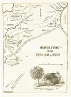
- Black Point, Scarborough, ca. 1633 - 1728
- Contributed by: Maine Historical Society
- Date: circa 1633
- Media: Ink on paper, map
-
Buy
-
- Item 108858
-

- Plan of 200 acres on the Western Side of Kennebec River, Frankfort Plantation, 1758
- Contributed by: Maine Historical Society
- Date: 1758
- Media: Ink on paper
-
Buy
-
- Item 108835
-

- Plan of lots 1-10, Fairfield, 1782
- Contributed by: Maine Historical Society
- Date: 1782-12-20
- Media: Ink on paper
-
Buy
-
- Item 11743
-

- Map of Harpswell, 1742
- Contributed by: Maine Historical Society
- Date: 1742-11-12
- Media: Ink on paper
-
Buy
-
- Item 12628
-

- Sebascodegan Island, 1741
- Contributed by: Maine Historical Society
- Date: 1741-08-06
- Media: Ink on paper
-
Buy
-
- Item 37701
-

- Penobscot Bay area, ca. 1750
- Contributed by: Maine Historical Society
- Date: circa 1750
- Media: Ink on paper
-
Buy
-
- Item 69934
-

- View from bathing beach, Ogunquit, ca. 1938
- Contributed by: Boston Public Library
- Date: circa 1938
- Media: Linen texture postcard
-
Buy