Search Results 355 items were found.
Keywords: to 1800
-
- Item 108858
-

- Plan of 200 acres on the Western Side of Kennebec River, Frankfort Plantation, 1758
- Contributed by: Maine Historical Society
- Date: 1758
- Media: Ink on paper
-
Buy


-
- Item 20784
-
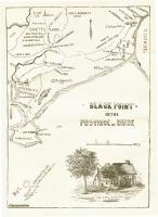
- Black Point, Scarborough, ca. 1633 - 1728
- Contributed by: Maine Historical Society
- Date: circa 1633
- Media: Ink on paper, map
-
Buy
-
- Item 102072
-

- Plan of Royalsborough, ca. 1766
- Contributed by: Maine Historical Society
- Date: circa 1766
- Media: Ink on vellum
-
Buy
-
- Item 28780
-

- Residence of Hannibal Hamlin, Paris, ca. 1900
- Contributed by: Hamlin Memorial Library and Museum
- Date: circa 1800
- Media: Postcard
-
Buy
-
- Item 6843
-

- A map of the boundary line explored in 1817
- Contributed by: Maine Historical Society
- Date: 1817
- Media: Ink on paper
-
Buy
-
- Item 12125
-

- Map of Cobbosseecontee Stream, 1765
- Contributed by: Maine Historical Society
- Date: 1765-07-29
- Media: Ink on paper
-
Buy
-
- Item 102068
-

- "Tract of land lying in Poland," 1798
- Contributed by: Maine Historical Society
- Date: 1798
- Media: Ink on paper
-
Buy
-
- Item 4182
-

- Plan of Rascoheegan alias Parker's Island, 1759
- Contributed by: Maine Historical Society
- Date: 1759
- Media: Ink on paper
-
Buy
-
- Item 10545
-
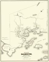
- Map of Ancient Falmouth from 1630 to 1690
- Contributed by: Maine Historical Society
- Date: circa 1630
- Media: Ink on paper
-
Buy
-
- Item 62539
-

- Chart of the Penobscot River, ca. 1779
- Contributed by: Maine Historical Society
- Date: 1779
- Media: Ink on paper
-
Buy
-
- Item 29062
-

- City Opera House stage, Biddeford, ca. 1890
- Contributed by: McArthur Public Library
- Date: circa 1890
- Media: Photographic print
-
Buy
-
- Item 58322
-

- Copy of early Surry map, ca. 1880
- Contributed by: Maine Historical Society
- Date: circa 1880
- Media: Ink on paper
-
Buy
-
- Item 116548
-

- Map of Lac La Croix, Iron Lake, and Crooked Lake, ca. 1825
- Contributed by: Maine Historical Society
- Date: circa 1825
- Media: Ink on paper
-
Buy
-
- Item 5179
-

- Eastern Cemetery, Portland, 1889
- Contributed by: Maine Historical Society
- Date: 1889
- Media: Blueprint
-
Buy
-
- Item 110945
-

- International water boundary between the United States and the Dominion of Canada, ca. 1893
- Contributed by: Maine Historical Society
- Date: 1893
- Media: Ink on paper
-
Buy
-
- Item 110967
-

- Map of Islands on Lake Huron, ca. 1820
- Contributed by: Maine Historical Society
- Date: circa 1820
- Media: Ink on paper
-
Buy
-
- Item 110997
-

- Map of the disputed portions of the New Brunswick and Lower Canada, 1839
- Contributed by: Maine Historical Society
- Date: 1839
- Media: Ink on paper
-
Buy
-
- Item 58323
-

- Copy of Surry and Ellsworth map, ca. 1880
- Contributed by: Maine Historical Society
- Date: circa 1880
- Media: Ink on paper
-
Buy
-
- Item 71152
-

- Bird's eye view, Vinalhaven, 1893
- Contributed by: Boston Public Library
- Date: 1893
- Media: Ink on paper
-
Buy
-
- Item 111036
-

- Lake of the Woods, ca. 1820
- Contributed by: Maine Historical Society
- Date: circa 1820
- Media: Ink on paper
-
Buy
-
- Item 116537
-

- St. John River boundary survey no. 2, 1843
- Contributed by: Maine Historical Society
- Date: 1843
- Media: Ink on paper
-
Buy
-
- Item 104302
-

- Recipe for reusing rose petals, ca. 1900
- Contributed by: Maine Historical Society
- Date: circa 1900
- Media: Ink on paper
-
Buy
-
- Item 6278
-

- The town of Falmouth, burnt by Capt. Moet, October 18, 1775
- Contributed by: Maine Historical Society
- Date: 1775-10-18
- Media: ink on paper
-
Buy
-
- Item 116503
-

- Manuscript map of Lake St. Clair, 1820
- Contributed by: Maine Historical Society
- Date: 1820
- Media: Ink on paper
-
Buy