Search Results 120 items were found.
Keywords: Early settlements
-
- Item 11724
-

- Map of Brunswick near the Narrows, 1737
- Contributed by: Maine Historical Society
- Date: 1737
- Media: Ink on paper
-
Buy


-
- Item 11974
-

- John Merrill lot, Topsham, 1762
- Contributed by: Maine Historical Society
- Date: 1762
- Media: Ink on paper
-
Buy
-
- Item 11928
-

- Fulton and Patten lots in Bowdoinham, 1759
- Contributed by: Maine Historical Society
- Date: 1759
- Media: Ink on paper
-
Buy
-
- Item 149687
-

- Map of Maine, ca. 1831
- Contributed by: Acadian Archives
- Date: circa 1831
- Media: Ink on paper
-
Buy
-
- Item 11929
-

- Flying Point at Maquoit Bay, Freeport, ca. 1770
- Contributed by: Maine Historical Society
- Date: circa 1770
- Media: Ink on paper
-
Buy
-
- Item 11715
-

- Plan of Maquoit Meadows, ca. 1720
- Contributed by: Maine Historical Society
- Date: circa 1720
- Media: Ink on paper
-
Buy
-
- Item 6360
-

- Samuel de Champlain, ca. 1600
- Contributed by: Maine Historical Society
- Date: circa 1600
- Media: Ink on paper
-
Buy
-
- Item 11714
-

- Map of Brunswick, 1725
- Contributed by: Maine Historical Society
- Date: 1725-04-08
- Media: Ink on paper
-
Buy
-
- Item 11717
-

- Brunswick, ca. 1718
- Contributed by: Maine Historical Society
- Date: circa 1718
- Media: Ink on paper
-
Buy
-
- Item 11718
-

- Land at Maquoit Bay, ca. 1740
- Contributed by: Maine Historical Society
- Date: circa 1740
- Media: Ink on paper
-
Buy
-
- Item 11721
-

- Plan of Land at Brunswick Narrows, 1741
- Contributed by: Maine Historical Society
- Date: 1741
- Media: Ink on paper
-
Buy
-
- Item 11722
-

- Map of Brunswick, lots on Merrymeeting Bay, ca. 1750
- Contributed by: Maine Historical Society
- Date: circa 1750
- Media: Ink on paper
-
Buy
-
- Item 11728
-

- Plan of a road in Brunswick, 1764
- Contributed by: Maine Historical Society
- Date: 1764
- Media: Ink on paper
-
Buy
-
- Item 11739
-

- Map of Harpswell, 1771
- Contributed by: Maine Historical Society
- Date: 1771-06-17
- Media: Ink on paper
-
Buy
-
- Item 11752
-

- North Yarmouth, ca. 1760
- Contributed by: Maine Historical Society
- Date: circa 1760
- Media: Ink on paper
-
Buy
-
- Item 11757
-

- John Robinson lot, Topsham, 1761
- Contributed by: Maine Historical Society
- Date: 1761
- Media: Ink on paper
-
Buy
-
- Item 11943
-

- Marquand Brunswick land, 1749
- Contributed by: Maine Historical Society
- Date: 1749-12-04
- Media: Ink on paper
-
Buy
-
- Item 11973
-

- Peletiah Haley's island, 1767
- Contributed by: Maine Historical Society
- Date: 1767-10-17
- Media: Ink on paper
-
Buy
-
- Item 11750
-

- Plan of road in Durham, 1770
- Contributed by: Maine Historical Society
- Date: 1770
- Media: Ink on paper
-
Buy
-
- Item 20784
-
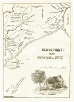
- Black Point, Scarborough, ca. 1633 - 1728
- Contributed by: Maine Historical Society
- Date: circa 1633
- Media: Ink on paper, map
-
Buy
-
- Item 11927
-

- Thomas Wilson lot, Topsham, 1764
- Contributed by: Maine Historical Society
- Date: 1764
- Media: Ink on paper
-
Buy
-
- Item 11733
-

- Noyes, Skinner, and Merrill lots, Topsham, 1762
- Contributed by: Maine Historical Society
- Date: 1762-01-05
- Media: Ink on paper
-
Buy
-
- Item 11736
-

- Lots on Cathance River, Topsham, 1764
- Contributed by: Maine Historical Society
- Date: 1764-02-28
- Media: Ink on paper
-
Buy
-
- Item 11751
-

- North Yarmouth road, Yarmouth, ca. 1760
- Contributed by: Maine Historical Society
- Date: circa 1760
- Media: Ink on paper
-
Buy