Search Results 222 items were found.
Keywords: Early map
-
- Item 6843
-

- A map of the boundary line explored in 1817
- Contributed by: Maine Historical Society
- Date: 1817
- Media: Ink on paper
-
Buy


-
- Item 149687
-

- Map of Maine, ca. 1831
- Contributed by: Acadian Archives
- Date: circa 1831
- Media: Ink on paper
-
Buy
-
- Item 109022
-

- Disputed lot E, Brunswick, 1811
- Contributed by: Maine Historical Society
- Date: 1811-09-03
- Media: Ink on paper
-
Buy
-
- Item 33847
-

- Champlain's map of Saco Bay and the Saco River, 1605
- Contributed by: McArthur Public Library
- Date: 1605
- Media: Photographic print
-
Buy
-
- Item 12200
-

- Maps of lots on the Androscoggin River, ca. 1760
- Contributed by: Maine Historical Society
- Date: circa 1760
- Media: Ink on paper
-
Buy
-
- Item 37703
-

- Kennebec and Sagadahok rivers plan, 1755
- Contributed by: Maine Historical Society
- Date: circa 1755
- Media: Ink on paper
-
Buy
-
- Item 9359
-

- Maine, from the United States Gazetteer, 1795
- Contributed by: Maine Historical Society
- Date: 1795
- Media: Ink on paper
-
Buy
-
- Item 66609
-

- Map of Mt. Desert Island printed on postcard, ca. 1935
- Contributed by: Boston Public Library
- Date: circa 1935
- Media: Linen texture postcard
-
Buy
-
- Item 12572
-

- Small Point, Phippsburg, 1731
- Contributed by: Maine Historical Society
- Date: 1731
- Media: Ink on paper
-
Buy
-
- Item 4177
-

- Province of Maine, ca. 1801
- Contributed by: Maine Historical Society
- Date: circa 1801
- Media: Paper
-
Buy
-
- Item 10537
-

- Mare Point, Brunswick, 1717
- Contributed by: Maine Historical Society
- Date: 1717
- Media: Ink on paper
-
Buy
-
- Item 105015
-

- Figure de la Terre Neuve, grande riviere de Canada, et cotes de l'ocean en la Nouvelle France, 1618
- Contributed by: Maine Historical Society
- Date: 1607
- Media: Ink on paper
-
Buy
-
- Item 11928
-

- Fulton and Patten lots in Bowdoinham, 1759
- Contributed by: Maine Historical Society
- Date: 1759
- Media: Ink on paper
-
Buy
-
- Item 12934
-

- Land granted to William and Charles Cushing, Hallowell, 1771
- Contributed by: Maine Historical Society
- Date: 1771-10-03
- Media: Ink on paper
-
Buy
-
- Item 10067
-

- Perley Farm, Gray, ca. 1780
- Contributed by: Maine Historical Society
- Date: circa 1780
- Media: Ink on paper
-
Buy
-
- Item 12944
-

- Plan of James Burns lot, 1764
- Contributed by: Maine Historical Society
- Date: 1764
- Media: Ink on paper
-
Buy
-
- Item 12933
-

- Wing's Mill Pond settlers' lots, ca. 1795
- Contributed by: Maine Historical Society
- Date: circa 1795
- Media: Ink on paper
-
Buy
-
- Item 20784
-
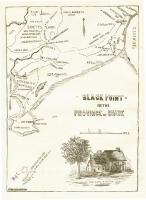
- Black Point, Scarborough, ca. 1633 - 1728
- Contributed by: Maine Historical Society
- Date: circa 1633
- Media: Ink on paper, map
-
Buy
-
- Item 11715
-

- Plan of Maquoit Meadows, ca. 1720
- Contributed by: Maine Historical Society
- Date: circa 1720
- Media: Ink on paper
-
Buy
-
- Item 12626
-

- Mereconege Neck, Harpswell, ca. 1780
- Contributed by: Maine Historical Society
- Date: circa 1760
- Media: Ink on paper
-
Buy
-
- Item 9714
-

- Nouvelle Ecosse ou Partie orientale du Canada, 1778
- Contributed by: Acadian Archives
- Date: 1778
- Media: Ink on paper
-
Buy
-
- Item 11454
-

- Fort Land, Brunswick, 1763
- Contributed by: Maine Historical Society
- Date: 1763-08-11
- Media: Ink on paper
-
Buy
-
- Item 12561
-

- Lots on Tinkham's Pond, Kennebec Patent, ca. 1800
- Contributed by: Maine Historical Society
- Date: circa 1800
- Media: Ink on paper
-
Buy
-
- Item 12630
-

- Upper end of Long Reach, Bath, 1728
- Contributed by: Maine Historical Society
- Date: 1728-11-18
- Media: Ink on paper
-
Buy